News
Where You Can Find 15 of the Best Hikes in Southern California

Hiking and being one with nature offers a lot of benefits for your overall health and well-being. So if you’re in Southern California, check out these ten best hiking spots and experience the great outdoors.
Hiking is a favorite activity of outdoor enthusiasts and thrill seekers out there. But hiking is more than just fun – it also offers a plethora of benefits that can help improve one’s physical, mental and emotional health and well-being. According to numerous studies, hiking helps improve blood pressure and blood sugar levels and reduces your risk of heart disease and diabetes. It also builds muscle and bone strength, and aids in controlling or maintaining weight. So if you’re a fitness buff, hiking should be at the top of your list.
For nature lovers, hiking and experiencing the great outdoors can offer a feeling of joy and serenity, away from the usual hustle and bustle of everyday life. Countless research has proven that taking regular nature walks helps improve your mood, invites positive emotions and lowers risk of depression and anxiety disorders. Hiking is also a great stress management technique. Seeing the scenic view of nature presents a restorative power that helps ease stress levels – it never fails to calm the nerves, invigorate the body and lift the spirits. So if you’re looking for the ultimate relaxation and stress-relief, or if you just want to “unplug” from technology or your hectic schedule – put on your hiking shoes, head out, and enjoy the beautiful scenery around you.
If you’re from Southern California, then you’re in for a treat! Southern California is home to some of the best hiking spots in the country and has a lot to offer to hikers and outdoor lovers. In this blog post, we’ve narrowed them down for you – some of these hiking trails are popular destinations, and some are hidden gems that are waiting for you to discover. Check out these great hiking spots throughout Southern California and enjoy!
| Hike / Trail | Distance (Round Trip) | Elevation Gain | Time | Difficulty | Season | Reviews | Map | Dogs Allowed | Pictures | Description |
| Temescal Canyon to Skull Rock | 4.6 mi | 1135 ft | 2.5 hrs | Moderate | All | Yelp | Map | No | Photos | |
| The Vital Link Trail to Verdugo Peak | 5.8 mi | 1835 ft | 3 hrs | Challenging | All | Yelp | Map | Yes | Photos | |
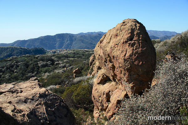
| Mishe Mokwa Trail to Sandstone Peak | 6.1 mi | 1656 ft | 3 hrs | Moderate | All | Yelp | Map | Yes | Photos | |
| Runyon Canyon | 3 mi | 675 ft | 1.5 hrs | Easy | All | Yelp | Map | Yes | Photos | |
| Mt San Antonio (Baldy) | 10.3 mi | 3950 ft | 7 hrs | Strenuous | Spring, Summer, Fall | Yelp | Map | Yes | Photos | |
| Los Liones Trail to Parker Mesa | 7.3 mi | 1292 ft | 4 hrs | Moderate | All | Yelp | Map | No | Photos | |
| Cahuenga Peak | 3 mi | 872 ft | 2 hrs | Challenging | All | Yelp | Map | Yes | Photos | |
| Vincent Gap to Mt Baden-Powell | 8 mi | 2818 ft | 5 hrs | Challenging | Spring, Summer, Fall | Yelp | Map | Yes | Photos | |
| Malibu Creek State Park | 8 mi | 224 ft | 3.5 hrs | Moderate | All | Yelp | Map | No | Photos | |
| Sam Merrill Trail to Echo Mountain | 6 mi | 1503 ft | 3 hrs | Moderate | All | Yelp | Map | Yes | Photos | |
| Solstice Canyon | 6 mi | 800 ft | 2 hrs | Easy | All | Yelp | Map | Yes | Photos | |
| Eaton Canyon | 3.8 mi | 592 ft | 1.5 hrs | Easy | All | Yelp | Map | Yes | Photos | |
| Vasquez Rocks | 3.4 mi | 310 ft | 2 hrs | Moderate | Spring, Fall, Winter | Yelp | Map | Yes | Photos | |
| Franklin Canyon Park | 3 mi | 160 ft | 1.5 hrs | Easy | All | Yelp | Map | Yes | Photos | |
| Santa Anita Canyon to Sturtevant Falls | 8.7 mi | 1660 ft | 4.5 hrs | Moderate | All | Yelp | Map | Yes | Photos |
Temescal Canyon to Skull Rock
This hike gives you opportunities to climb the more challenging steep canyon or to a more relaxed and gradual slope. For those of you who are adverse to the sun, the steep canyon has more shade while the relaxed climb gives those who love the sun more exposure to it. You can also see the skull rock formations on the trail which contribute to the hike's appeal.
For dog lovers, make sure you keep your dogs at home for this hike as they are not allowed on the main trail.
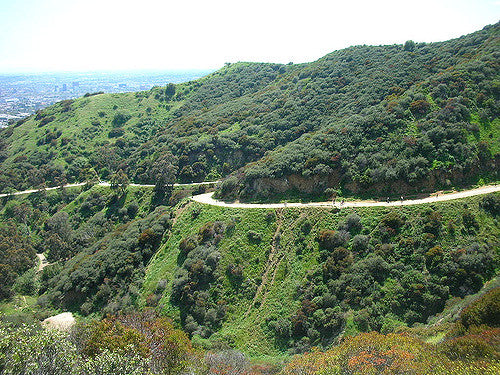
The Vital Link Trail to Verdugo Peak
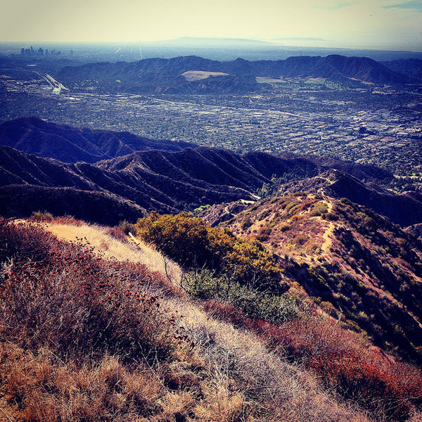
Sitting between the Santa Monica and San Gabriel Mountains, the Verdugo Peak is the tallest peak in this range, and the Vital Link Trail is the gateway to witnessing the magnificent views on the way up. The hike will approximately take an hour (60 minutes) to 3 hours (180 minutes), depending on how professional the hiker is. The trail is about 5.8 miles or around 9.3 kilometers and is pretty steep with an elevation of around 2000 ft.
The Vital Link Trail to Verdugo Peak is one of the best hikes in Southern California, providing hikers with great views of downtown Los Angeles and the surrounding San Gabriel Mountains. Hikers will be greeted by breathtaking views of the Crescenta Valley and San Fernando Valley, add to this the San Gabriel Mountains as a backdrop on the east side for an even more picturesque site. Trekking the Vital Link Trail to Verdugo Peak will provide a good sweat, nice views, and a real challenge.
Mishe Mokwa Trail to Sandstone Peak
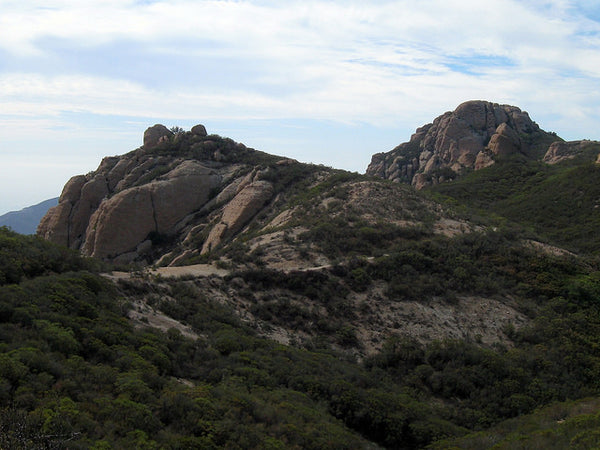
Perhaps one of the most, if not the most, revered best day hikes in California. The trail features a great scenery and spots to venture on the way to the highest peak in Santa Monica Mountains. The elevation gain is not that noticeable on the majority of the trip; however, it will be quite a hike on the first few miles of the Mishe Mokwa Trail. It will be considerably easy to go back and forth the 6.1 miles (9.817 kilometers) for intermediate hikers and even novice hikers who are up for a challenge. Hiking the Mishe Mokwa Trail will take an average of 3 to 4 hours (180 to 240 minutes) to finish to-and-fro the almost 1700 ft elevation gain.
The Mishe Mokwa Trail has a pet-friendly path to Sandstone Peak so dogs can roam around the off-leash park area. It is highly advisable to bring lots of water, wear hiking shoes, use hiking sticks, and bring dog leash since this is not an off-leash park. It’s worth noting that the only shady part of the Mishe Mokwa Trail is around the Split Rock Picnic Area.
Runyon Canyon
Runyon Canyon Trail loops around 130 acres of land located in Los Angeles, California. Runyon Canyon Trail is a 2.5 mile heavily trafficked loop trail located near Los Angeles, California that offers scenic views and is rated as moderate. If you’re looking for a place to hike, watch great views. As the park lies outside the Hollywood Boulevard, it is common to spot some trail runners, dog walkers, and hikers along the path.
The Runyon Canyon Trail is one of the easier forms of best hikes in Southern California. It only takes around 1 hour and 30 minutes to complete the 3 miles (1.61 kilometers). The elevation for the entire trail is just around 700 ft. So it is not that difficult of a hike for most of the part.
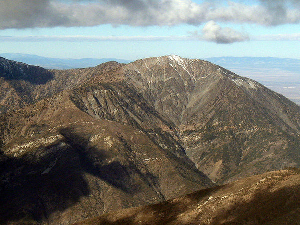
Mt. San Antonio (Mt. Baldy)
The Mount San Antonio Trail or better known as Mount Baldy is the main attraction of the San Gabriel Mountains. It spans a hiking distance of 10.3 miles (16.58 kilometers). It has an elevation gain of around 3,900 ft. And is considered as one of the more strenuously best hikes in Southern California. Because Mt Baldy has an elevation of 10,064 feet above sea level, not too many trees can grow near the mountain peak. Hence, it was given the name “Mt. Baldy”.
Most of the trails here are relatively easy even for beginners. But take note that there are still areas that are dangerous. Mount Baldy caters to a dog-friendly trek and is one of the best day hikes in California because it gives hikers a beautiful view of the Sierra Nevada Mountains to the North, San Jacinto and San Gorgonio Peaks to the east, and a magnificent sight of both the Catalina island and the Pacific Ocean to the west.
Los Liones Trail to Parker Mesa
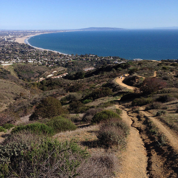
The Los Liones Trail is one of the best hikes in California spanning around 7.3 miles (11.75 kilometers) and an elevation of 3,950 ft. Hikers could finish the trail in about 2 to 4 hours (120 to 240 minutes), which is how it is usually described as – a moderately steep hiking trail. It is worth noting that mountain lions are living in the area. Although there are rare sightings of the wild animals, it is highly advisable to trek the trail with caution. Additionally, there are reports of rattlesnakes sighted in some parts of the trail. Los Liones Canyon is not a dog-friendly place so bringing dogs, in leash or not, is not permitted. Ticks are present in the bushes so avoid big bushes, wear long pants and sleeves, and always remember to brush off and clean before leaving the trail.
On the positive side, the Los Liones Trail winds a verdant path of ivies and faunas that would surely look magnificent in spring. The lush track offers a scenic view of the Santa Monica Bay, and as it arrives at a ridge, there is a bench that weaves a much picturesque sight of the Santa Monica Bay, Pacific Palisades, and the Pacific Ocean beyond.
Cahuenga Peak
The 12th highest peak in the Santa Monica Mountains is the Cahuenga Peak, located on the west side of the Hollywood sign. Climbing to the summit provides hikers with a spectacular 360-degree panoramic view of the San Fernando Valley and the Los Angeles Basin. From the west of Cahuenga Peak is the Wonder View Trail or the now-called Burbank Peak Trail, which is home to the Wisdom Tree. The Aileen Getty ridge trail is over the top of Cahuenga Peak from Burbank, along the ridge to the Hollywood sign found at the top of Mount Lee.
Hiking both pathways, which span around 3 miles (4.83 kilometers) back and forth with an elevation gain of around 872 feet, is easy to moderate for all hikers. Note that both trails to Cahuenga Peak are rugged single paths and provide hikers with decent to moderate workout and more solitude than other routes to the famed Hollywood Sign. One of the best hikes in California, this route is a shorter alternative to the traditional 6.4-mile (10.3 kilometers) walk from the Brush Canyon Trail or the 3.5-mile hike from Hollyridge Trail going to the Hollywood Sign.
The trail is near Los Angeles, California and it features a beautiful array of wild flowers. It is primarily used for hiking and running as it is accessible all year-round. Dogs can be brought on this trail but must be kept on their leashes.
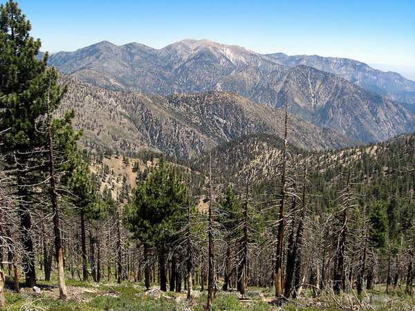
Vincent Gap to Mt Baden-Powell
Lord Anthony Baden-Powell was a British scout who founded the Boy Scouts organization in 1907. The trail is one of the known best hikes in California leading through a path full of flora – Incense Cedar and different kinds of pines including Ponderosa Pine, Jeffrey Pine, Limber Pine, and Lodgepole Pine. Hiking to the Mount Baden-Powell takes approximately 5 hours (300 minutes) back and forth the 8-mile (12.88 kilometers) terrain with an elevation gain of 2,818 feet and 6,565 feet above sea level.
The Vincent Gap, formerly known as Vincent Gulch Divide, is near the San Gabriel Mountains at the northeastern end. Furthermore, it divides the drainage of Big Rock Creek in the north and the San Gabriel River in the south from Mount Baden Powell.
Hiking Vincent Gap out-and-back trail is a great challenge but will help build strength and stamina for bigger hikes. On the positive side, it also paves the way for beautiful sceneries, and stunning mountain and desert views. It is a dog-friendly trail, but mountain bikes are prohibited in the area.
Malibu Creek State Park
Another one of the best hikes in California is Malibu Creek State Park with a creek running throughout the middle of the state park. This magnificent landscape sprawls through a magical view complete with cosmic gorges, toothed mountains, jagged cliffs, and a lot more. This natural beauty was formed over a million years ago; and to date, nature helps in creating the magnificent sceneries and landscapes all over Malibu Creek State Park. There are around 11 favorite trails and more than 60 camping grounds and other high-quality amenities scattered all around the park giving hikers and adventurers various options to choose from.
Hiking the 8 miles (12.87 kilometers) path would take roughly 3.5 hours (210 minutes) since it is considered an easy to moderate trail. Dogs are only allowed up to the campsites and parking lot. Also, snakes are mostly spotted during spring months so staying on track while trekking is highly advisable. Furthermore, there are lots of ticks in the area, and some even carry diseases; hence, checking clothing and exposed skin is a must. Note that the trails at Malibu Creek State Park have loose rocks so wearing the proper hiking gear should be observed at all times.
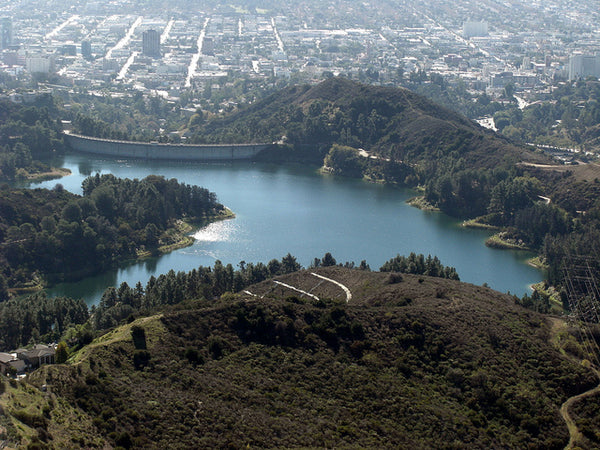
Sam Merrill Trail to Echo Mountain

Trekking the Sam Merrill Trail to the Echo Mountain will be a rewarding experience. As one of the best hikes in California, the path is rich in history with historical markers and plaques placed along the ruins and an old railroad trail through the mountains. On the Echo Mountain lie the famous Echo Mountain House ruins, a hotel built by Thaddeus Lowe in the late 1800s. During the day, no roads were available to get to this hotel; instead, people reach it via an inclined railway that climbs over 1,000 feet. The hotel burned to the ground in a fire, but there are remnants of the grandeur that once shone brightly atop Echo Mountain.
So in the 1940s, Sam Merrill thought it was important to create a hiking trail to the ruins, so he worked diligently to make a path. After dying in 1948, the Sierra Club, which Merrill was an active volunteer of, named the then Echo Trail after him.
The trail spans a distance of 10.4 miles (16.74 kilometers) back and forth, making the moderate hike last for around 3 hours (180 minutes). It ascends steadily at an aggressive pace with an incline of about 1,503 feet. Hikers will get to see astounding views of Las Flores Canyon past the line full of spring wildflowers and Chaparrals, vistas, and more.
Solstice Canyon
Solstice Canyon lies within the Santa Monica Mountains. The 6-mile (9.67 kilometers) round-trip hike features various options for a no-fuss trek alongside a creek within a vast canyon. Perhaps the greatest attraction to this trail that makes it one of the best hikes in California is the small waterfall beside the some of the oldest building ruins in Malibu. The trail provides choices for easy, moderate, or challenging hikes through a line of coastal shrubs and plants. Hikers can enjoy picnics or shady strolls along the Solstice Canyon Trail.
The most famous of all ruins is the stone cottage that was built by Matthew Keller in 1865. It is believed that this stone building, which has survived many wildfires before succumbing to wreckage in 2007, is the oldest existing ruins in Malibu.
The trail, which ascends at an elevation of about 800 feet, can be finished within 2 hours (120 minutes). Dogs are allowed on the trail but will have to be kept on their leashes while in the park.
Eaton Canyon
Eaton Canyon lies at the foothills of San Gabriel Mountains and is initially called “El Precipicio” or “The Cliff” by Spanish settlers because of its steep gorges. It was named after Judge Benjamin Eaton who built the first Fair Oaks Ranch House in 1865 and who was the first person to use the creek as an irrigation system to grow grapes and fruits.
It is one of the must-see best hikes in California because of its stunning waterfalls and natural scenery. Additionally, the Eaton Canyon Trail spans approximately 4 miles (6.44 kilometers) out and back with a minimal elevation gain of around 592 feet. This makes the Eaton Canyon Trail pretty much easy with a few streams to cross over. The path can be very crowded especially leading to the waterfalls so the hike can go for around 1.5 hours (90 minutes).
Note that dogs are allowed in the area and that it gets crowded during the weekends and on some parts of the weekdays.
Vasquez Rocks
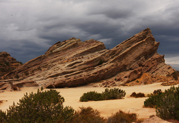
The Vasquez Rocks were formed millions of years ago by rapid erosion during uplift and soon exposed by activities at the San Andreas Fault. Formerly home to the Tataviam people before the Spanish arrived, this group of sandstone formation is located outside Los Angeles. In the early 1980s, Tiburcio Vasquez, one of the known most notorious bandits in California, used the rocks to avoid being captured by the authorities; hence, his name has been associated with the Vasquez Rocks since then.
The Vasquez Rocks Trail is a 3.4 miles (5.47 kilometers) hike that features an array of beautiful wild flowers. The trail is rated moderate with an elevation gain of 310 feet and will take hikers approximately 2 hours (120 minutes) to trek back and forth. It is considered as one of the easier best hikes in California with a diverse option for activities all year-round.
Dogs can use this trail although they should be kept on leashes and cannot roam freely. Adventurers should bear in mind that there are rare sightings of mountain lions and snakes in the area; hence, should follow the trail always.
Franklin Canyon Park
The Franklin Canyon Park traces its beginnings back to 1914 when William Mulholland and the Los Angeles Department of Water and Power decided to build a reservoir in the upper part of the canyon. At the time, it was used by the family of oil baron Edward L. Doheny as their summer retreat house. And in the 1930s, the canyon started to be used for filming.
Located just 10 minutes away from Beverly Hills, the Franklin Canyon Park has 8 miles of hiking trails and 3 acres of lake to explore. It has three main trails – Hastain, Discovery, and Berman trails – that are ideal for novice to intermediate hikers. The Hastain Loop is one of the easier best hikes in California that offers a decent workout, fantastic views of Century City and Beverly Hills, and a less-than-crowded area spanning 2.7 miles (4.35 kilometers) with an elevation gain of 160 ft that can be hiked within 2 hours (120 minutes). Dogs are allowed on leashes within the park’s vicinity. Bikes are also allowed within the wider sections of the trail but not on the single tracks.
Santa Anita Canyon to Sturtevant Falls
Hiking Santa Anita Canyon to Sturtevant Falls is one of the most rewarding best hikes in California. It is situated above the Sierra Madre and Arcadia Cities and in the San Gabriel Mountains. There are more than forty miles of trails winding through the area that leads to bubbling brooks, spectacular views, and places of solitude. Additionally, wildlife is abundant so seeing animals along the trails, including ticks and rattlesnakes.
Sturtevant Falls is one of the highest waterfalls, at 55 feet, in the Santa Anita Canyon and one of the most popular. During times when the water is flowing well, it becomes an impressive sight. The loop spans about 8.7 miles (14 kilometers) back and forth, making it a moderate hike that can be finished within 4.5 hours (270 minutes). Furthermore, dogs are allowed in the area granting that they are on their respective leashes.